Countryside Drive to Uarbry

Uarbry


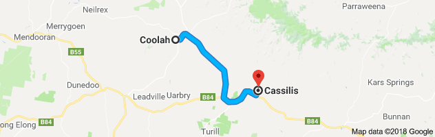
Journey time is approx. 43 minutes / distance 46 km one way.


Drive to the small village of Uarbry by exiting town via Campbell Street/Cassilis Road.  Approximately 18km from Coolah turn right into Tongy Lane.

Of note on Tongy Lane are the location of a number of old stories – John Jones, the owner of the Turee Station in 1837 was attacked by an employee Edward Tufts, with a pair of shears – wounded in the thigh and groin he died a few days later and was buried on the property.   Mary Ellliot, whose husband William Elliott held New Turee in the 1860s, died at Turee in 1864.   Her above ground sandstone vault stands in a paddock about a kilometre off the Lane near the grave of John Jones.   Mary often wore a red dress and old timers claimed that on many occasions at night an apparition in a red dress was sighted near her vault.     The nearby Croppy Creek also features a headless rider scaring late night travellers.    Also along the Lane was the place where two troopers and their horses were killed and buried and there were old reports of a bobbing light seen in the area at night.

The last property on Tongy Lane is Tongy Station whose sandstone homestead was destroyed by the Sir Ivan fires in 2017, however the historic woolshed can still be seen on the right hand side of the the Lane.  Tongy Station was initially owned by Robert Fitzgerald, an ex-convict who through hard work and charm increased his fortune.   In 1838 he had 41 assigned convicts on Tongy mostly engaged in clearing the land.    Tongy came into the Bailleau family in 1923 and is still held by a family member.

Continue down the Lane to the T-junction, and turn right on the Golden Hwy.  A few km further and the village of Uarbry is on your right (although this is the second village, an earlier village being located to the left on the plains but prone to flooding in its first few years, causing the move to higher ground and its present position).   Mentioned as early as 1833 by the Surveyor Robert Dixon  “Arrived at Uarbry and obtained for Captain Piper a native guide”.   Always a small village, it nevertheless was full of community spirit holding horse races and having a tennis and cricket club and of course a pub,all in the late 1800s.   The Mudgee Guardian of 30 July 1900 reported that Joe and Jimmy Governor  “called at Robinson’s, Uarbry … asking for George Cohen and France Piper, and wanted to know if they were home or not…” – this was during the time of the Governor’s rampage (made famous by the film The Chant of Jimmy Blacksmith).

Uarbry Church before 2017


The remains of Uarbry Chruch after Sir Ivan Fire 2017.


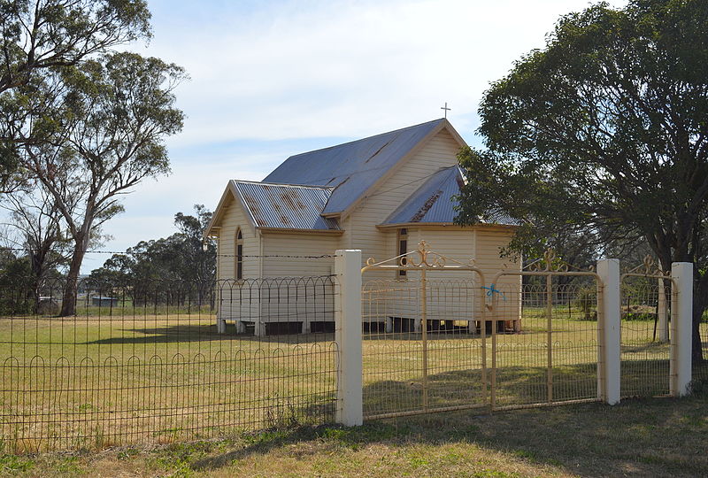
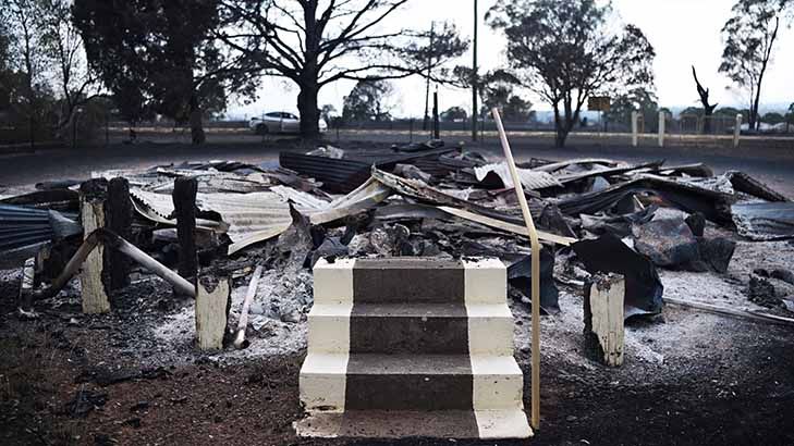
Uarbry was almost completely destroyed by the Sir Ivan fire in February 2017, losing its charming little church, community built hall and all but two residences, and fire damage is still very evident around the town as it slowly recovers.  The cemetery at the rear of the town (on a short but unsealed road) has mostly survived and contains some touching family stories, most notably that of the Hobbins family.

Settling near Leadville (over the hill to the west of Uarbry) at Old Castle (now Dhu Robin) in the 1850s,  Martin Hobbins left his family at Christmas 1876 to go droving, not returning until May 1877.  During this time his eldest daughter Catherine died, followed 2 weeks later by Teressa aged 9, twelve days later Ambrose age 6 died, all from diptheria.   On April 26th Martin’s wife Catherine died while giving birth to twins and a month later Mary, aged 18 also succumbed to the disease.   Martin arrived home soon after.   He is said to have cut, shaped and inscribed all the headstones with his own hands whilst mourning, then carrying them by horse and dray to the cemetery at Uarbry.  Martin died 13 years later and is also buried there.

More history on Uarbry, Tongy and Turee Stations can be found in the book “Around the Black Stump” by Roy Cameron, a copy is available to view in the Coolah Library.

To download this drive in PDF format, please click here: http://coolahnsw.com.au/UARBRY%20DRIVE.pdf

Drive to Historic Cassilis

Cassilis

Journey time is approx. 42 minutes / distance 56km one way.

Coolah to Cassilis

Drive to the east of Coolah through rolling countryside to the village of Cassilis.   Take Campbell Street which turns into Cassilis Rd out of town, driving over the Coolaburragundy River, the road lined with Lombardy Poplar trees that were planted early in the 20th century – a wonderful photo of them as young trees was taken by a young Max Dupain – a print of which can be seen in the Coolah Library.   You will see another avenue of the Poplars to the right of the road which leads to the old bridge site that was washed away by a huge flood in 1955.   About 7km out on the road, on Perrams Hill is a lookout with a fabulous view to the west over the Coolah valley.   Continue following the road.

There are two roads to Cassilis, the first off Vinegaroy Road takes you into the back of Cassilis – note that the road is dirt and dry weather access only.   Alternately continue along Vinegaroy Road to the Golden Hwy, turn left.   Continue east past the Ulan Road turn on the right that heads to Mudgee, (also known locally as the “Barrier Gates”.   Believed to be constructed in the late 1800s the gate was part of a rabbit proof fence.   Known as a stopping place for teams on their way to and from Morpeth, there were apparently sightings of several ghosts there).    Cassilis is well signposted and is on your left a few kilometres further down the Golden Highway.   The trees lining the entrance road to the town were planted in honour of local soldiers who fought in world conflicts.

Cassilis is a small historic township with a few buildings dating from the 1800s.  Originally a depot of mounted police with a lock up and court house erected in 1835 and headquarters on the border police from 1836 to 1839 on the property “Cassilis” owned by the Busby family (still owned by a descendant).  The town was developed on the neighbouring property of Dalkeith, along the Munmurra Brook, and was initially a private village.   Once more populous than Mudgee it was soon eclipsed after the village stalled with the death of the owner John O’Regan who died intestate and no further lots were able to be sold until 1874.  In 1860 the population of the Police District of Cassilis (which included Coolah) was 1060, including “45 Chinese” and the only piano in town was at the Cassilis Hotel.    The original Dalkeith cemetery is on a steep slope adjacent to the present day Catholic Church, only a couple of the grave sites can still be seen as it was not preserved, however reportedly over 100 burials are contained there.

The notable buildings still in Cassilis are the sandstone buildings that were the Court House (now a general store) and Police Station in Branksome St that date from approx. 1858.   The aboriginal bushranger Jimmy Governor worked as a police tracker at Cassilis and lived behind the police station.   This was prior to his working at Breelong which started his three month rampage resulting in ten murders.    The sandstone Royal Hotel in Buccleugh St was erected in about 1870 on the site of an earlier hotel called the Traveller’s Rest.

Royal Hotel, Cassilis, NSW

A grand post office was built almost opposite the Royal Hotel and cost over 2000 pounds by the time it was occupied in 1882.   It was unfortunately demolished in the 1960s.  An elegant residence dating from around the late 19th Century near the corner of Buccleugh and Branksome Streets, once belonged to the town’s female doctor, Dr. Bray.  The low long building on Branksome Street, not that far from Dr. Bray’s house was once a Chinese Emporium and before that a general store, dating back to the late 1800s.  The Anglican church (St. Colomba of Iona) near the entrance of the town built in 1899, is a well kept building worth a visit.

More information on Cassilis can be obtained from the Merriwa Historical Society.

To download this drive in PDF format, please click here: http://coolahnsw.com.au/CASSILIS%20DRIVE.pdf