Did you know there is a lava tube in the Coolah Tops National Park?
This video from Cheryl Parkes shows her group finding it!
Home of the Black Stump
Information for people visiting the Coolah district. Please be sure to click “Older Posts” at the end of this page to see more suggested drives.
Did you know there is a lava tube in the Coolah Tops National Park?
This video from Cheryl Parkes shows her group finding it!
Excerpts from an article in the Sydney Morning Herald in 2004 on Coolah. 20 years later and things haven’t changed much!
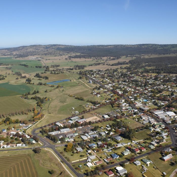
“Coolah
Service town located on no major route and consequently dependent on the economic prosperity of the surrounding rural area.
Coolah is the principal town of the Coolah Shire. It is situated by the Coolaburragundy River, 89 km north-east of Mudgee and 352 km from Sydney. It functions as a service centre to the surrounding district which is given over to the production of wheat, cattle, mixed farming, timber, fat lambs and wool.
Prior to white settlement the area the Coolah valley was occupied by the Kamilaroi and Wiradjuri peoples. In 1823 explorer Allan Cunningham became the first known European in the district when he came across Pandora’s Pass, the route over the Warrumbungle Range on to the Liverpool Plains. The district was surveyed in 1832 and squatters soon followed, in search of fresh pastures.
The Black Stump Wine Saloon was established about 10 km north of Coolah at a junction where the road split, heading north-east to Gunnedah and north-west to Coonabarabran. The pub was apparently named after the nearby Black Stump Run and Black Stump Creek. As if to strengthen the claim it is said the Aboriginal name for the area means ‘place where the fire went out and left a black stump’. For these reasons locals argue that the Coolah area lies at the origin of the Australian saying ‘beyond the black stump’, meaning beyond the limits of civilisation, though it has other contenders .
The railway did not arrive until 1910. Before that time, travellers en route to Sydney had to journey by a horse-drawn vehicle to Mudgee, by Cobb & Co coach to Penrith and then by rail to the city.
Coolah Crafts
The craft shop has all manner of crafts and home-made condiments. It is open from 10.00 a.m. to 4.30 p.m. daily at 37 Binnia St.
McMaster Park
McMaster Park, at the corner of Binnia and Booyamurra Sts, has a pleasant garden and lawn area, a tourist guide map. barbecues, play facilities and an early 20th-century bullock wagon.
Coolah Tops National Park
NSW’s most recently declared national park, Coolah Tops, is situated on a plateau 30 km east of Coolah where the Liverpool Range, the Warrumbungle Range and the Great Dividing Range meet. Long occupied by the Kamilaroi Aborigines, who have left numerous traces of their presence, Allan Cunningham became the first known European in the area in 1823.
The park is essentially eucalypt forest atop basalt soils. Wildlife is abundant. One of the most prevalent species is the greater glider, a one-metre-long possum which can glide for up to 100 metres.
The Forest Road (unsealed) runs right through the park. It is not to be used by any vehicles in wet weather. At the park entrance is an information board. Another 3 km brings you to a 1-km side road on the right that leads to a carpark and picnic site from where there is a 1.5-km walking track which leads to the spectacular Norfolk Falls and on to the Bald Hill Creek Falls where there is a no-facilities bush camping area.
As you continue north along Pinnacle Rd you will pass, on the right-hand side of the road, the signposted departure points for the Racecourse Walking Track (6 km) and, about another kilometre north, the Bundella Walking Track (7 km). The latter leads past a lookout area. The two eventually join.
At the end of Pinnacle Rd there is a short walking track to the Pinnacle Lookout, a steep basalt outcrop with fine views to the north and west to the Warrumbungles. A rough walking track heads south from the lookout to the basalt caves (the largest being 70-m deep).
About 24 km east of Pinnacle Rd, on the left-hand side of The Forest Rd, is Breeza Lookout which proffers extensive views out over the Liverpool Plains. There is a small picnic area and an information bay. If you are fit there is a short but steep track from here to Shepherds Peak protruding from the northern escarpment.
To get there head out of town on the road to Cassilis. After 2 km turn left on to the Coolah Creek Rd. After about 19 km there is a turnoff on the right to Coolah Tops National Park .
Cunningham Memorial and Pandora’s Pass
If you ignore the turnoff to the national park and stick to the left it will take you, after 3 km, to a lovely picnic site on the northern side of Coolah Creek where you will find the Allan Cunningham Memorial.
If you continue north for 4 km it leads to Pandora’s Pass (815 m above sea-level). There are excellent views back over the Coolah Valley and north over the Liverpool Plains.
The Black Stump Rest Area
There are several towns in Australia which lay some claim to being at the origin of the saying ‘beyond the black stump’, meaning beyond the limits of civilisation. The Black Stump Wine Saloon was established about 10 km north of Coolah at a junction where the road split, heading north-east to Gunnedah and north-west to Coonabarabran. The pub was apparently named after the nearby Black Stump Run and Black Stump Creek. As if to strengthen the claim it is said the Aboriginal name for the area means ‘place where the fire went out and left a black stump’.
A rest area has been established by the road at the approximate site of the old saloon. There is, of course, a black stump to mark the spot.
For those with a keen interest in Aboriginal history, the grave of King Togee is to be found 29 km west of Coolah on the left-hand side of the Neilrex Rd, just past the ‘Langdon’ homestead. There is little to see other than a weather-worn sandstone headstone surrounded by four white posts with a sign overhead reading: ‘TOGEE KING OF THE BUTHEROE TRIBE’. King Togee was friendly with the early settlers but was speared to death by a young man named Cuttabush who later became the king of a Coonabarabran sub-tribe.
Fossicking for Fossils
To access the Narangerie Leaf Fossil Bed head south-west on the Dunedoo Rd for 18 km then turn right on to the Narangerie Rd. The soft white rock of the roadside gravel pit is 3 km along this road to the right.
Fishing
Rainbow trout can be found in the upper reaches of the Coolaburragundy River during the trout season (first October weekend to Easter). Yellowbelly, carp and catfish are caught in the lower reaches.”
Original article at https://www.smh.com.au/lifestyle/coolah-20040208-gdkq0c.html
Colin and Mara (Colin and Mara’s Travels on Youtube) came through Coolah recently and stayed in our free RV camping spot. Watch from 2min mark. It includes some very cool drone footage of the town and surrounds.
Other free camping spots are available in the district, some have no facilities but are happy to provide an off-road area. Click the following link to see campsites within a 50km radius of Coolah township: https://directory.fullrangecamping.com.au/?a=true&s&rad=50&runits=km&lat=-31.8241855&lon=149.7197655&frc_loc=coolah&paged=1
Some other links to camping in Coolah Tops National Park:
https://www.campsaustraliawide.com/look-for-giants-at-coolah-tops-national-park-new-south-wales/
https://www.anycamp.com.au/campsite/the-barracks-campground